Urban planning and regeneration in Aotearoa New Zealand is posed with a number of complexities, related to how decisions are informed through current evidence for better social, environmental and economic outcomes at the city and neighbourhood scales. Planners often face the challenge of having to comply with several planning processes which recurrently do not have an integrated approach to environmental, social and economic assessment of planning and regeneration scenarios. Adding to this complexity, there is a lack of geospatial tools to support planners in evidence-based decisions, or to support the visualisation of planning and regeneration scenarios to involve other actors in the process (i.e. decision-makers, developers, iwi, and resident communities). Our research develops tools to provide support to planning practitioners in assessing, comparing, examining, and visualising the trade-offs of regeneration scenarios, and build business-cases to advocate for alternative approaches to sustainable urban regeneration.
This research develops a geospatial toolkit to support evidence-based decision-making in urban planning and regeneration in Aotearoa New Zealand. Planning decisions are complex, and urban models can provide a more comprehensive perspective on impacts of such decisions on the underlying interdependencies. For this, we have developed two distinct geospatial tools: ENVISION and ENVISION SCENARIO PLANNER (ESP).
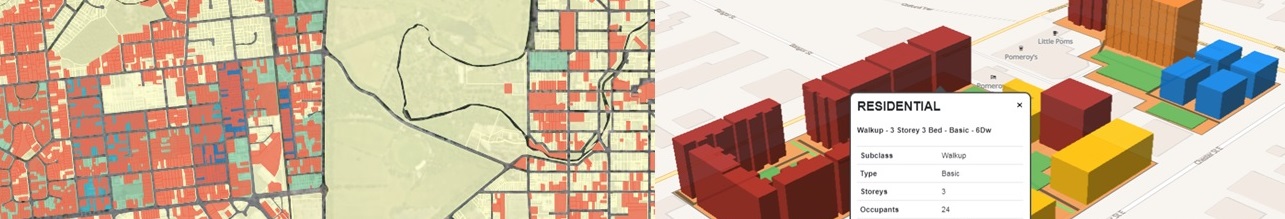
ENVISION - Where to regenerate? It is a map-based tool which aims to support the identification of urban areas suitable for specific regeneration strategies at the city-region scale, through the analysis of demographic and property-level data.
ENVISION SCENARIO PLANNER (ESP) - How to regenerate? It enables the modelling alternative regeneration scenarios and the assessment of their environmental, social and economic impacts at the neighbourhood scale.
Stakeholder engagement is a key component of this research, and we have been working with diverse planning authorities to assess the suitability and usability of the geospatial toolkit and identify areas for improvement considering local specific needs and priorities across the country.
This project is funded by the National Science Challenge 11 “Building Better Homes, Towns and Cities: Ko ngā wā kāinga hei papakainga.
Media mention
ESP featured on Architecture Now website
ESP nominated as finalist for New Zealand Spatial Excellence Awards
Tools featured on National Science Challenge 11 website
Related publications
Schindler, M., Dionisio, R. and Kingham, S. (2020): Challenges of Spatial Decision-Support Tools in Urban Planning: Lessons from New Zealand’s Cities Journal of Urban Planning and Development, 146(2). DOI 10.1061/(ASCE)UP.1943-5444.0000575.
Dionisio, R., Schindler, M. and Kingham, S. (2020). Tools for sustainable change: How can spatial decision-support tools support transformative urban regeneration? International Journal of E-Planning Research, 9(2).DOI 10.4018/IJEPR.2020040102.